
Jeremy Allen
I started my career as an active-duty U.S. Army intelligence analyst, researching North Korea's military, al-Qaeda's propaganda and recruiting, and violent social movements around the world. All of that was a big bummer, so I taught myself R and returned to school for a degree in philosophy.
I joined RStudio (now named Posit) in 2021 as a Customer Success rep for the Life Sciences and Public Sector teams. I spent 2024 as a Sales rep for the Public Sector team. I thrive when I help technical and non-technical audiences understand each other, so now I am on Posit’s Product Marketing team, leveraging all of my public sector and programming experience to ensure Posit understands unique public sector data science requirements!
Did I mention I also have a photography degree and did a short tour as a commercial photographer and image retoucher? My wife and I actually met in photography school. We now raise our daughter in Atlanta, after about seven years in Colorado and, before that, Florida.
I zealously maintain my whiskey, coffee, tea, photography, cats (we have 3!), and R hobbies outside of work.
I keep several kinds of things on this website: mainly photo portfolios but also personal notes about books, philosophy, politics, and family. I also link to interesting things other people create. I am a lifetime student of philosophy and social theory. I am insatiably curious and willing to travel unknown routes to see what I turn up, where I end up, who I meet, and how I change. I hope to see you along the way.
Why 18 chains?
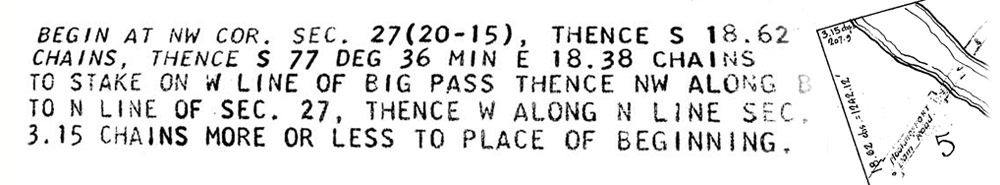
"Thence S 18.62 chains, thence S 77 deg 36 min E 18.38 chains"
This text and map snippet are from an early twentieth-century property survey and map of my dad's property in northern Louisiana. Back then surveyors used a fixed-length chain and a compass to measure and demarcate property boundaries. Start at a corner, plant a stake. Walk on an azimuth toward the second corner. Record how many chain lengths to get there. Get an azimuth to the third corner and go. Record how many chain lengths to get there. Repeat until you get to the last corner. From there, get the azimuth back to the first corner stake and go. Record how many chain lengths to get there. Now you are back at the beginning - similar to doing philosophy and social theory, trying to demarcate concepts and meaning methodically.